Sénanque, Gordes, Village de Bories and back to Sénanque through the Sénancole Gorge
Cultural but also physically demanding day hike
hike
easy
3 h 45 min
yes
yes
built-up area
mountain
Introduction
You can basically start this tour at any of the sections, but the description starts in the north in Sénanque and continues clockwise. The reasons are as follows: shade in the ascent from the monastery (even in midsummer if you leave before 9 am), arrival in Gordes well before noon to stock up on good products for the snack (market in summer on Tuesday), to the Village de Bories is when everyone goes for lunch, so there is less activity there and on the road, lunch break with the possibility of a siesta on the old terraces in the Sénancole gorge. And we save the longest march for the end. If you have paused and snoozed long enough, then there is enough shade in the gorge in the afternoon. You just have to rest long enough!
The facts
7,6 km total distance
3 h 45 min walking time
290 m total elevation
orientation easy except in the gorge
mark 55% of the total distance
35% quiet side streets
30% easy trails
10% dirt roads
10% country road
5% city alleys
5% moderate trails
dangers do not enter the gorge during a thunderstorm
children only if they have appropriate walking experience
useful picnic stuff
required hiking boots, hiking equipment and water
GPS coordinates (WGS84) of start and end point 43.930647,5.189106
downloads ![]()
![]()
No reproduction is permitted without the written consent of the author. (id3164)
Monastery of Sénanque seen from the road to Gordes
The path allows for views that cannot be had from the road.
Public transport
Only Gordes is directly accessible by public transportation: one bus per day on the line 917 between Cavaillon and Apt, information at Zou! (only french). It ist useful to complain about this bad service at the tourist offices of the region.
Access by car
Sénanque and Village des Bories are easily accessible from Gordes and are well signposted. The narrow road (D117) between Gordes and Sénanque is one-way in summer. To return to Gordes you have to take a detour via Murs in this case.
Useful parking spaces
At Sénanque and at the Village des Bories there are sufficient and also free parking areas. It is better not to go to the village of Gordes, parking spaces are scarce there in high season and also chargeable.
Hints
Due to the length of the tour, a visit to the Monastery of Sénanque is not recommended. It is better to do this on another day. On Christian holidays, such as Easter, it can be very busy here. The one-hour tour is only of limited interest for children.
The whole region is a zone with a high risk of forest fires. In summer, but also in other seasons when it is very dry or strong winds, access to the forest areas can be regulated. As a result, the roads may be closed to traffic and/or the trails prohibited to hikers. Current information: Map for access to the forests of the Vaucluse department (only french). The map shows the colours green, yellow, orange and red which correspond to levels of danger.
The sections
- Easy between Sénanque and Gordes (well-marked long-distance trail)
- Then also simply to the Village des Bories, less shade here
- More difficult in terms of orientation and terrain, some markers may be missing, the path in the second part of the gorge can be slightly overgrown
In summer it is very hot throughout. There is usually not a drop of water in the gorge, nor on the rest of the tour. Drinking water is only available in Sénanque (entrance area of the monastery), in Gordes and at the Village de Bories (in the toilets near the ticket office). You can only eat in Gordes. In Sénanque and at the Village des Bories there aren't even any snacks.
Section 1: Sénanque - Gordes
➙ 2,9 km ... 1 h min ➚ 70 m ➘ 105 m ↝ easy
65% easy trails, with marks
10% quiet side streets, few marks
25% country road, few marks
The clues
- Sénanque, 385 m, starting point at the car park
- Signpost on the D117, Côte de Sénancole, 460 m, highest point
- Signpost La Rouguière, 370 m, district of Gordes
- La Combe, 325 m, valley cut just before Gordes
- Gordes, 350 m, place worth seeing and shopping facilities
Ascent to the city via the old connecting route.
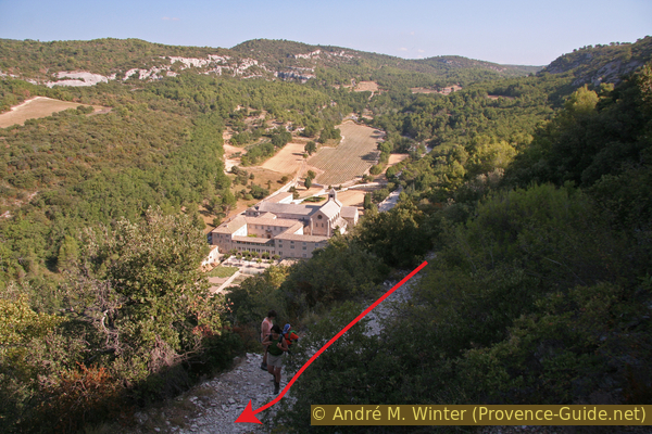
The uphill path starts in the middle or at the bottom of the parking lot. This is how you get to the old connection path to Gordes. We cross the facility's supply road, which is otherwise closed to traffic. The path continues to climb, but at first you stay well below the road to Gordes. After a few disturbing trees, the view of the monastery complex opens up (picture above). Here you have a far better and quieter place than up on the street, where you can only stop for a very short time.
If you start before 9 a.m., you always stay in the cool shade on the climb, even in midsummer.
No reproduction is permitted without the written consent of the author. (id3165)
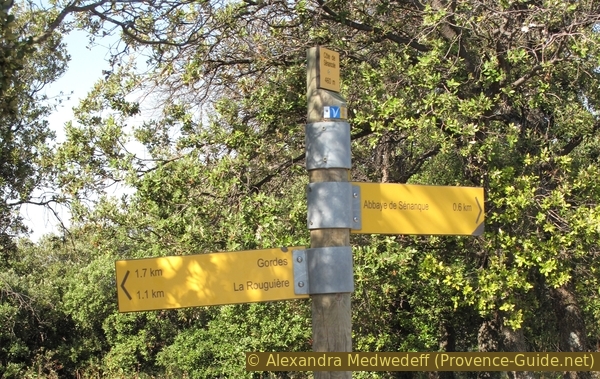
Signpost on the Côte de Sénancole
The markings are good here (Côte means slope shoulder).
The path reaches the above-mentioned road from Gordes to Sénanque, which you may have used for the access. Here you have to continue in the direction of the march (towards Gordes). After about 100 m we leave the road to the right again and take the gravel road, which at first seems a bit chaotic (signpost Côte de Sénancole, 460 m, to Gordes, La Rouguière).
The picture shows the gorge of the Sénancole from the slope shoulder. We will come back through it later.
No reproduction is permitted without the written consent of the author. (id3166)
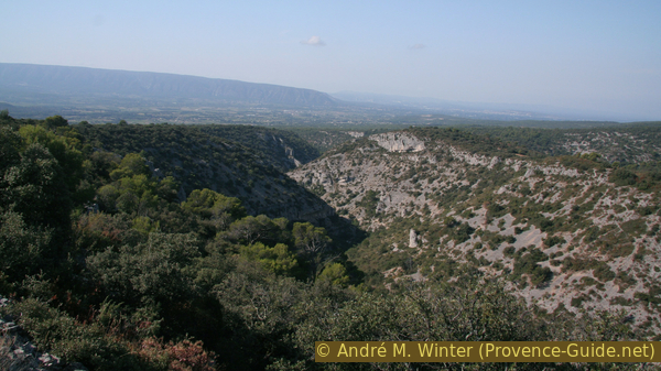
View of the Sénancole gorge, our way back
The hiking trail is clearly and well marked, leaving a few other trails to the left and right. A gravel road is crossed at 427 m above sea level.
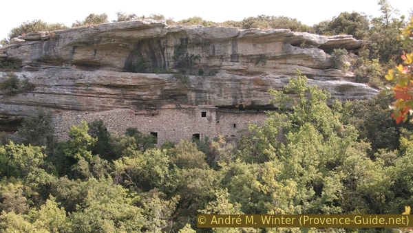
Continuing south-east, the path now descends between dry stone walls. Several bories (dry stone huts) can be seen near the trail. These are the first of this tour, but certainly not the last. This stretch is pleasant and picturesque, since all possible types of dry stone construction accompany us here.
After a quarter of an hour you realize that you are coming to the main street and immersing yourself in the noisy civilization.
No reproduction is permitted without the written consent of the author. (id3167)
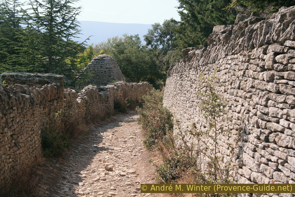
GR6 long-distance hiking trail on the old path from Sénanque to Gordes
The leisurely path between stone walls makes a right turn and the descent is steep and bumpy over a section where old cart tracks are clearly visible. This is how you get on to asphalt, which will now accompany us for a longer time (signpost, 370 m, to Gordes), keep left here below. You loop into the busy D117, which we follow in the direction of Gordes (turn right). We are now in the district of La Rouguière. Some mulberry and fig trees are ripe here from the end of August and can sweeten the otherwise less nice section.
No reproduction is permitted without the written consent of the author. (id3168)
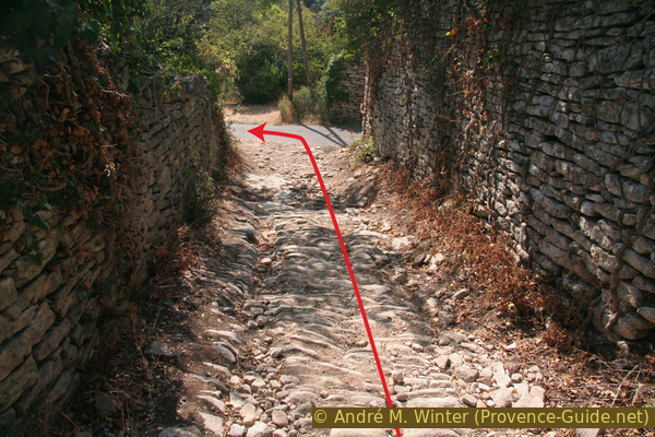
Old cart path
Now look carefully on the left side of the road for red and white markings. There is a shortcut just after and opposite the Hôtel du Domaine de l'Enclos. If you miss this, it's not too bad either, then you go out of the bend in the road by taking the first big street on the left. On the Route de la Combe, we pass the central car park of Gordes (usually full) and continue to ascend towards the village centre. You will pass some nice but expensive hotels.
Shortcut left
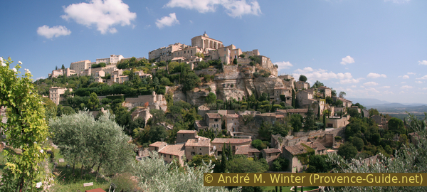
Brief visit of Gordes: the village is included in the Association of the Most Beautiful Villages in France. Worth seeing is the castle in the center, the church (the interior, however, hides the foundation walls of the 13th century), chapels and the streets "en calade", a regional way of using cobblestones on edge to be able to pave steeper streets. market is on Tuesdays between Easter and All Saints' Day.
No reproduction is permitted without the written consent of the author. (id3103)
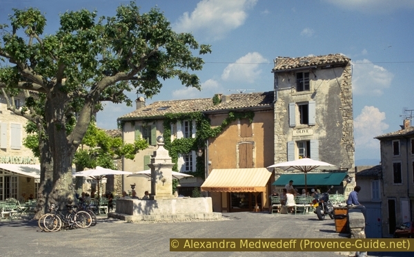
Place de la Mairie in Gordes, empty at midday
calade = cobblestones
église = church
château = castle
From the castle, go down the Rue de l'Église to the "caves" (vaulted cellars) and the written "point de vue" (viewpoint). The view is not too great, but here we are walking on a very beautiful calade. With this method, the stones are placed vertically to cover steeper sections and prevent slipping.
No reproduction is permitted without the written consent of the author. (id3169)
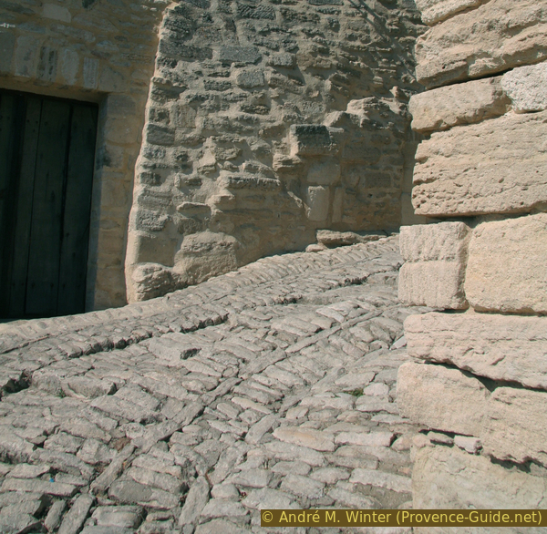
Calades on Rue du Belvédère
Section 2: Gordes - Village des Bories
➙ 2,9 km ... 50 min ➚ 50 m ➘ 105 m ↝ easy
15% city alleys, faulty marks
85% quiet side streets, without marks
The clues
- Gordes, 350 m, place worth seeing and shopping facilities
- La Combe, 294 m, valley cut when leaving Gordes
- Signpost Bel Air (off the D15), 315 m, district of Gordes
- Les Grangiers, 265 m, hamlet of Gordes
- Village de Bories, 290 m, open air museum (no snacks)
Leave Gordes towards Village des Bories, unfortunately along the road.
Back uphill from the Belvédère and turn left into Rue de la Porte de Savoie. Here along some beautiful houses downhill (now it is called Rue Jean Deyrolle) and so on down to the valley. Once at the bottom, we follow the sign "Point de vue" (viewpoint) up and not the other markings that lead down. The concrete road leads between nice gardens to said vantage point. Along this small street, where no cars stray, one always has good views of Gordes, its villas and hotels with the gardens. However, you are not high enough to see the castle. The photo was taken there.
No reproduction is permitted without the written consent of the author. (id3170)
Gordes seen from Bel Air
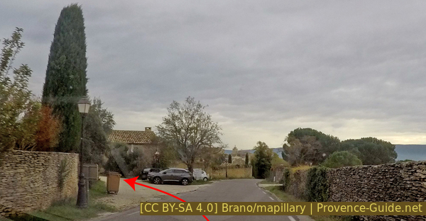
We go further up and thus come to the main road D15 without turning off, here you can see motor tourists desperately looking for parking spaces in summer. We cross the main road at an angle and get into an alley with a dead end sign. There is a signpost on the left and the road is bordered by a dry stone wall on the right. After a few meters there is a driving ban for cars and now there are high stone walls on both sides that hide chic villas. You can briefly see the D15 on the left, but we continue straight on to the hamlet of Les Grangiers (signpost for Village des Bories), keep right here (the GR long-distance trail Les Monts du Vaucluse continues straight on).
Now there is no viable alternative to the access road to the museum. A few cars will overtake us here in the next few kilometers. However, having started from Sénanque at 10 a.m., it is now just past noon and there will be few cars. Some bories are hidden in the forest, but the road remains a bland affair. However, other paths would have far more gradients without really leading to the goal.
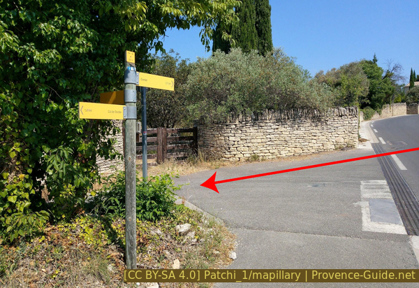
Signpost at Bel-Air and direction to take
We come from the right.
Visit of the Village des Bories open-air museum: Admission for adults EUR8.- (2024). So you don't have to climb into any bories in the fields, which are also mostly privately owned. The individual types of bories are briefly introduced, you can walk freely in the area.
The Bories stand on a bare limestone plateau. In summer there is hardly any shade except in the stone houses themselves. If you are now looking for a picnic spot, see the next section!
No reproduction is permitted without the written consent of the author. (id2933)
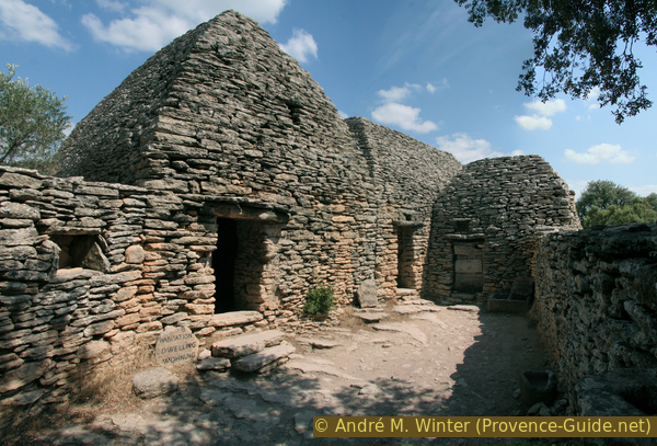
In the Village des Bories near Gordes
Section 3: Village des Bories - Gorges de la Sénancole - Sénanque
➙ 1,8 km ... 2 h min ➚ 170 m ➘ 80 m ↝ easy
30% easy trails, faulty marks
45% dirt roads, without marks
20% moderate trails, old marks
The clues
- Village de Bories, 290 m, open-air museum
- Sénancole, 230 m, dry river bed
- The valley splits in two, 265 m, keep right
- Canyon: always take the best possible lower path
- Abbaye de Sénanque, 380 m, worth seeing (no snacks!)
- Monastery car park, 385 m, end and back at the starting point
Danger! Do not descend into the valley of the Sénancole when there is a risk of thunderstorms, as the valley, which is otherwise always dry, can quickly fill up with water. The case is very rare, and even less so in the summer, but one better be forewarned. The valley was created by water and its catchment area is quite large. The gorge is only very narrow in a few places, so you can always escape to higher ground, but the terrain remains rocky and impassable away from the valley floor. Even a little water from previous rain in the creek bed can be disturbing, after all you have to cross the creek bed several times. The only viable exits from the gorge in case of problems are as follows:
- At the level of the Village des Bories, 245 m: climb back to the Village des Bories on the right along the marked path.
- At the valley junction, 265 m: here you can also turn sharp right back onto the plateau and get to Gordes via La Basse Juverde. From the valley junction you can also turn left into the Grande Combe and later climb out of this gorge to the west (always keep left), but this takes you quite far away from civilization.
- 500 m after the valley fork, 290 m: marked path up to the right to Les Dilais: this brings you back to the section between Sénanque and Gordes.
No reproduction is permitted without the written consent of the author. (id3172)
Path on the ancient cultural terraces in the valley of the Sénancole
You can still find trees here from the time when these terraces were still cultivated.
ferme = farm
GR = long distance trail
hab. troglodytes = underground houses
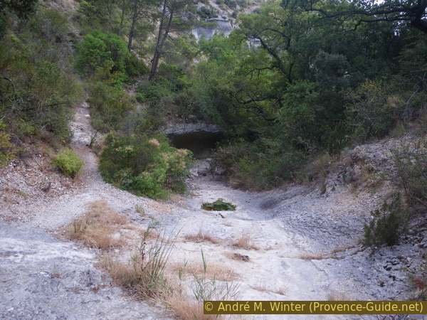
To get to the Sénancole gorge: from the southern (lower) car park, go straight south downhill. An old cobbled road descends over a wooded ridge and passes an old farm. Shortly before the valley floor, turn right onto a path (further down there is another junction with the GR long distance hiking trail Tour des Monts de Vaucluse). This is how we get to the valley of the Sénancole from below.
Now follow the yellow, sometimes blue markings. You walk on old cultural terraces, first to the right of the stream bed. Some dry stone buildings and also a large semi-cave built in can be seen on the left. Side paths lead to all these ruins, but there is a great danger of collapse everywhere!
Starting from the Village de Bories there is another marked trail into the gorge. It first heads west and then reaches the valley junction (see below). It's shorter, but has the shortcoming of not leading past the old terraces, and it's a great place to rest and take an afternoon nap. You would also miss the cave dwellings.
No reproduction is permitted without the written consent of the author. (id3173)
Maison de la Croix des Baux ruin
Shortly after the built-in half-cave on the left side of the valley, on the right next to the path, is an old stone wine basin (photo), which was originally covered by a borie. The grapes were pressed on site and the must was caught in them. The must was not stored here, but it was easier (because less) to transport than the unpressed grapes. In the Vaucluse department there are still many better preserved so-called "cuves vinaires rupestres".
The path often changes sides of the valley, but the Sénancole should always be dry. Nevertheless, watch out for thunderstorms and get out if necessary!
No reproduction is permitted without the written consent of the author. (id3174)

Stone basin for wine most in the Sénancole valley
grotte = cave
combe = canyon
It's hard to get lost in the valley. However, there is an important but poorly marked key point about 1 km after the start. It is a valley bifurcation, a prominent rock (photo) marks this area. At this point you also come across a small foundation wall that crosses the path. Here you have to keep to the right, cross the creek bed and scramble to the other bank (depending on the degree of rinsing). There is a path on the left that seems much more comfortable, but it leads into a wrong valley (Grande Combe). You only see the signpost when you stand on the other bank.
No reproduction is permitted without the written consent of the author. The permission of use was kindly given to Provence-Guide.net on 10 October 2019. (id3175)
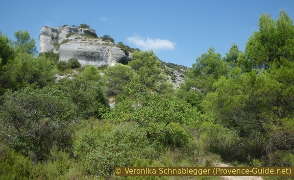
Prominent rock at the valley junction
On the left the valley of the Grande Combe (further back Combe de Douin) and on the right we continue in the gorge of the Sénancole.
After the valleys fork, you just have to follow the further course of the valley. The valley keeps getting narrower. Shortly after the fork, there is a small passage cave on the right (photo), which you can walk through.
No reproduction is permitted without the written consent of the author. (id3176)
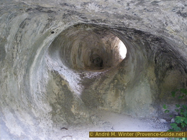
Small passage cave in the valley of the Sénancole
A few minutes later, when the valley bends to the left, a path branches off to the right, crosses the bed of the stream and then climbs quite quickly. This is a marked trail that goes across the plateau via Les Dilais to Gordes or Sénanque. Don't go up here, stay in the valley!
In a narrow section of the valley, the Sénancole has dug into the side wall and created an overhanging section in the limestone. The old stone wall testifies that shepherds used to herd their animals here (photo).
No reproduction is permitted without the written consent of the author. (id3177)
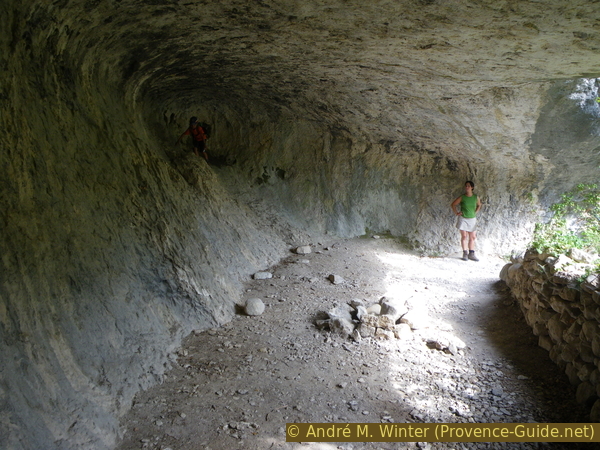
Large semi-cave in the Sénancole gorge
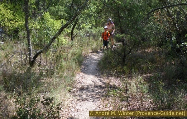
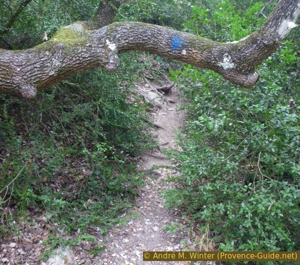
The path often changes sides, often climbing relatively high on the left side of the valley, but rarely on the right side of the valley (where only the path to Les Dilais goes up). We stay further in the valley, the path is definitely no longer recommended for sneaker tourists, good mountain boots offer the best grip. Sparse marking with blue dots.
No reproduction is permitted without the written consent of the author. (id3178)
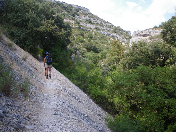
Hikers on a small heap of scree
All creek crossings have to be forded, but there is hardly any water in the Sénancole. Please note the warnings at the beginning of the section anyway !
Here we had tried to walk directly in the creek bed, but thorny bushes quickly thwarted the attempt.
No reproduction is permitted without the written consent of the author. (id3179)
The path crosses the creek bed again
There is no longer an official hiking trail here, but the path is marked in blue and probably kept clear by hunters. There is prickly maquis here, but we got through without much scratching even in shorts and T-shirts.
No reproduction is permitted without the written consent of the author. (id3180)
Path in the valley of the Sénancole south of Sénanque
Sometimes the path climbs up the rock, but these sections are always short and not very high. This is how you avoid high steps in the valley floor or sections that are too overgrown.
It is on the way from the south to the Monastery of Sénanque, but there is no official entrance here. The facility is bypassed on the right until you come back to the main entrance and the parking lot behind to our starting point.
No reproduction is permitted without the written consent of the author. (id3181)
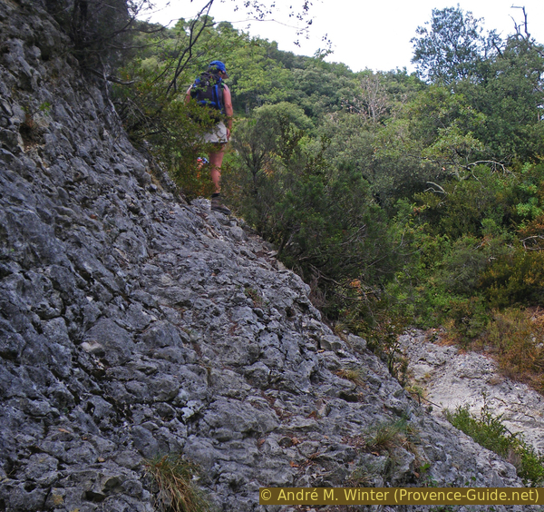
Hiker on a short rocky crossing
Visit to the Abbaye de Sénanque: EUR8,50 for adults in 2024, the technically good tour lasts over an hour, so it is not for children. Attention, in the low season the opening times are very limited.
Sources and additional information
It is better to use a good topographical hiking map: this tour is on the IGN map "Cavaillon, Fontaine-de-Vaucluse, Parc naturel régional du Luberon", scale 1:25000, 3142OT.
If you don't want to bother with a paper map, you can also use mapping apps on your cell phone. On the one hand, it is the Géoportail app from the official map service IGN. However, it requires access to the data network and this is sometimes difficult in canyons or remote locations.
Alternatively, you can use apps that store data directly on the device. They're generally not free, but they don't cost much. We mainly use OSMAnd, here it is possible to add contour lines, relief shading, markings and others. To store this data on your phone you need a lot of space.
Of course, one needs access to satellites for the GPS signal with any app. In some canyons this is not the case. Therefore, do not rely on the position shown, but read the map on your phone as you would read it on paper. Most apps are available for Android and iPhone. The applications usually allow us to record the route travelled and also view the GPS files offered for each of our hikes.
This page has been seen 197 times since 20 March 2024.
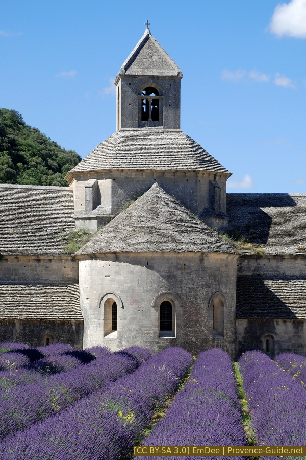
Cloister church of the Abbey of Sénanque and the lavender field