Dry stone buildings around Le Beaucet
Lone farms, bories and other abandoned constructions
hike
average
5 h min
far
yes
no
mountain
Introduction
This hike is aimed at anyone who is interested in rural drywall construction. The shelters so typical of Provence are now partly off the beaten track in the forest. Sometimes you have to fight your way through the prickly bushes. Because of these pathless sections, this tour can no longer be described as easy. However, there are circumhikes for these areas. In the background you always have views to Mont Ventoux.
The limestone landscapes of Provence are dotted with many different types of dry stone buildings. The best known are the round bories, simple conical shelters. The shape goes back to the type of construction: flat stones are placed one on top of the other in such a way that rainwater runs off to the outside, but the roof is closed inwards in the overhang. In this area in the Vaucluse there are still larger and rectangular dry constructions, often a farm is now attached. Entire farms have also been built under overhanging cliffs. Another speciality of the region are the must cisterns, which were dug directly into the bedrock. Of all these examples, you will see several examples on this hike.
The facts
13 km total distance
5 h min walking time
500 m total elevation
orientation few markings on roads and forest paths, a pathless section
mark 50% of the total distance
35% quiet side streets
25% easy trails
15% city alleys
10% dirt roads
10% forest roads
5% cross country
5% hard-to-recognize trails
<5% country road
dangers some sections run through private land
children yes
useful picnic stuff
required hiking boots, hiking equipment and water
GPS coordinates (WGS84) of start and end point 43.983185,5.11898
downloads ![]()
![]()
No reproduction is permitted without the written consent of the author. (id3242)
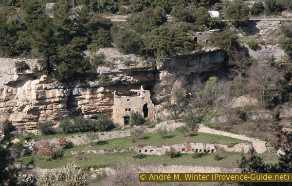
Courtyard of Carroufra under a rock overhang
On this hike we discover several bories and such structures under rocky outcrops.
Public transport
Getting to the starting point of the tour in public transport is not easy. From Avignon you can take the train to Carpentras every 30 minutes, look for Carpentras under TER PACA (only french), this is also where this railway line ends. When you come out of the train station, you are immediately at the bus station of the transport network Trans'Cove (only french). However, there are bus connections to Le Beaucet (line N) only for students and therefore at impossible times for hikers. Call taxis (Tàd, Transport à la demande) are, however, available at other fixed times. Registration at least 4 hours before departure.
From the bus stop, continue on the main road to get to the parking lot by the cemetery, where the description of the tour begins.
Access by car
Le Beaucet is a small village southeast of Carpentras. First follow the signs to Venasque, pass through St. Didier and continue to Le Beaucet.
Useful parking spaces
There is a small parking lot west of the village near the cemetery. It is enough large for the people living here and the few hikers. Here the tour begins. We ascend from here towards the little village.
Hints
The majority of the dry stone buildings on this tour are off the path with no other markings, a GPS device can be helpful for locating them.
Attention: All historical buildings are on private property. Visiting the building is usually only permitted until further notice. Under no circumstances should you climb over fences or disregard prohibition signs, which may also have been recently erected. This applies in particular to the must stone basin of La Lauze and the Mas de la Vachère. Most of the nearby residences are only occupied during the summer, so it's better to schedule this tour during the weekdays in the winter so as not to disturb anyone.
The whole region is a zone with a high risk of forest fires. In summer, but also in other seasons when it is very dry or strong winds, access to the forest areas can be regulated. As a result, the roads may be closed to traffic and/or the trails prohibited to hikers. Current information: Map for access to the forests of the Vaucluse department (only french). The map shows the colours green, yellow, orange and red which correspond to levels of danger.
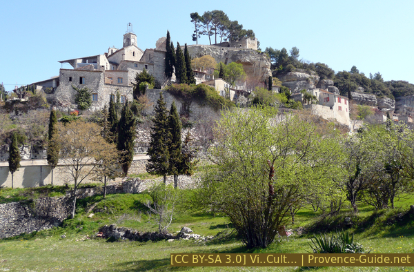
Le Beaucet seen from the bus stop
On the left you can see the cemetery wall.
The sections
- Climb towards the east between olive and cherry trees
- Pathless from La Lauze down to La Vachère farm
- Past the Carroufra cave dwellings to St. Gens
- Return to Le Beaucet via La Grande Cabane
Section 1: Le Beaucet - La Lauze
➙ 4 km ... 1 h 40 min ➚ 250 m ➘ 50 m ↝ average
20% city alleys, without marks
5% dirt roads, with marks
10% easy trails, with marks
5% country road, without marks
35% quiet side streets, without marks
25% forest roads, without marks
The clues
- Le Beaucet, 240 m
- Plateau de la Pelade, 300 m
- La Lauze, 460 m
Ascent to the plateau where most of the dry stone buildings are located.
No reproduction is permitted without the written consent of the author. (id3229)
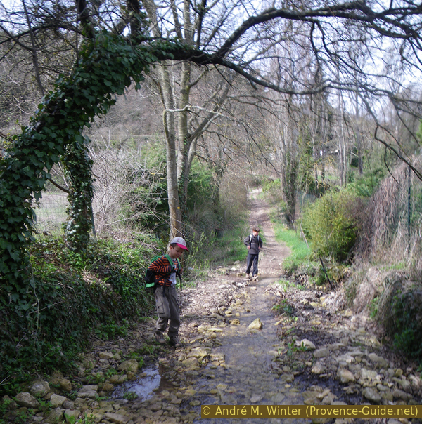
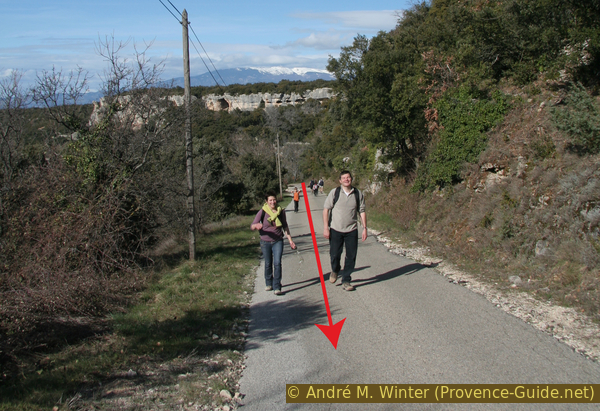
Damp start from the Route de Saint Gens in March
château = castle
Leaving the cemetery behind us, we climb up a cobbled road to the village. At the top, turn left into Rue Coste Chaude, which takes you past the church with the octagonal tower. Continue past the church in a northerly direction, descending through small alleys to the main gate of the old town. This is how we get to the Chemin de l'Ermitage, which we now follow to the east. We come down to the Route de Saint Gens and turn left here. However, at the first opportunity to the right in a field path in the valley floor. There may be some water here in winter.
We follow yellow markings between dry stone walls. After 200 meters, the easy path climbs noticeably to the D247 road. We ignore all signposts and turn right on the asphalt road. Go east-south-east for 250 meters and at the fork take the asphalted path on the right (arrow MV 110, the path is called Chemin de la Combe de la Péyrière). Orchards line the road, villages on hills and the great Mont Ventoux can be seen in the distance.
No reproduction is permitted without the written consent of the author. (id3230)
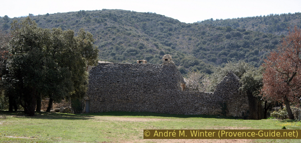
Mas de la Lauze
We ignore the following road to La Nauque on the left, the next right to Hameau de Carroufa as well and we always walk straight and slightly uphill. The road enters a holm oak forest and becomes an unpaved forest road. We continue to the La Lauze estate (signpost) on the right of the path. You cannot see the main house from the gate because it is hidden behind a cross-built dry stone hall.
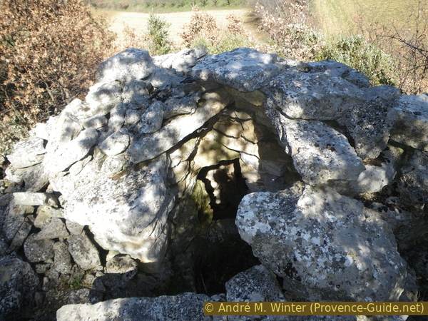
Just in front of the gate of La Lauze, a little hidden in the forest, is another rectangular borie. It has fallen into disrepair but is freely accessible.
No reproduction is permitted without the written consent of the author. (id3231)
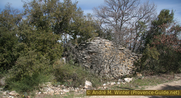
Damaged borie with opposite corbelled vault
Section 2: La Lauze - La Vachère
➙ 1,2 km ... 30 min ➚ 50 m ➘ 80 m ↝ challenging
10% hard-to-recognize trails, without marks
20% cross country, officially blocked
25% hard-to-recognize trails, without marks
15% cross country, officially blocked
35% dirt roads, without marks
The clues
- Pathless downhill east of La Lauze
- Wine cistern in the rock south of La Lauze, 440 m
- Large rectangular borie, 430 m
- Mas de la Vachère, 420 m
We are walking partly through private territory here.
If you are unsure or if new obstacles appear, go back about 800 metres along the road from La Lauze and look for a signpost on the right. A little later, the long-distance hiking trail GR91 turns off to the left. Pass the Carroufra farm, then turn left and continue on to la Vachère and Combe Mayaud.
cuve vinaire = must basin
The Mas de la Lauze property is surrounded by a dry stone wall. At the end of the wall and in a left turn, you can find a little-used path on the right between bushes. If you come to a signpost on the road, you have gone too far. La Lauze is bordered on the south by a rocky escarpment, our path leads under this rock wall. The path first runs down the dry valley floor, but soon turns to the rock on the right. So you go west with the rock on the right hand side.
After about 100 meters and a loss of barely 20 meters in height, there is a flat, grass-covered ramp in the rock on which you can enter the plateau on the right.
Attention, we are on private property here, access is strictly forbidden. Don't get in if you did see cars parked up in the yard!
We stay on the left at the edge of the cliff, on the right there are stone walls. The main building can be seen at the top right. 70 meters further you come to a dry stone building that looks like a borie on the cliff edge. It is a covered must stone pool. Grapes were crushed in two large tanks and the juice obtained was preserved for a while. This basin is carved into the bedrock and covered with an elongated borie to protect the wine must from rain and dirt.
The place was chosen because of the hard and massive stone.
Covered must stone pool by La Lauze
No wine was stored here, it was only an interim storage. The grapes were pressed here and only the grape must was transported down into the valley and into the villages. So there was less volume to transport.
The basins are carved directly into the bedrock, as are the rainwater drainage channels.
No reproduction is permitted without the written consent of the author. (id3232)
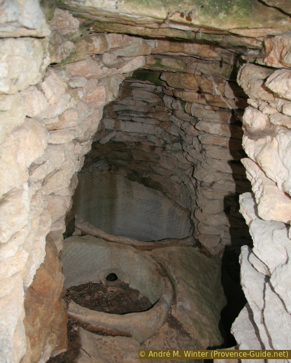
Covered double must stone pool by La Lauze
After viewing this rarity, return to the ramp along the same path at the top of the cliff.
Back on the foot the rock wall, we continue down to the east, passing under the fromer basins. There is an open source socket in the rock below.
No reproduction is permitted without the written consent of the author. (id3233)
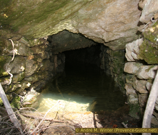
Source under the La Lauze plateau
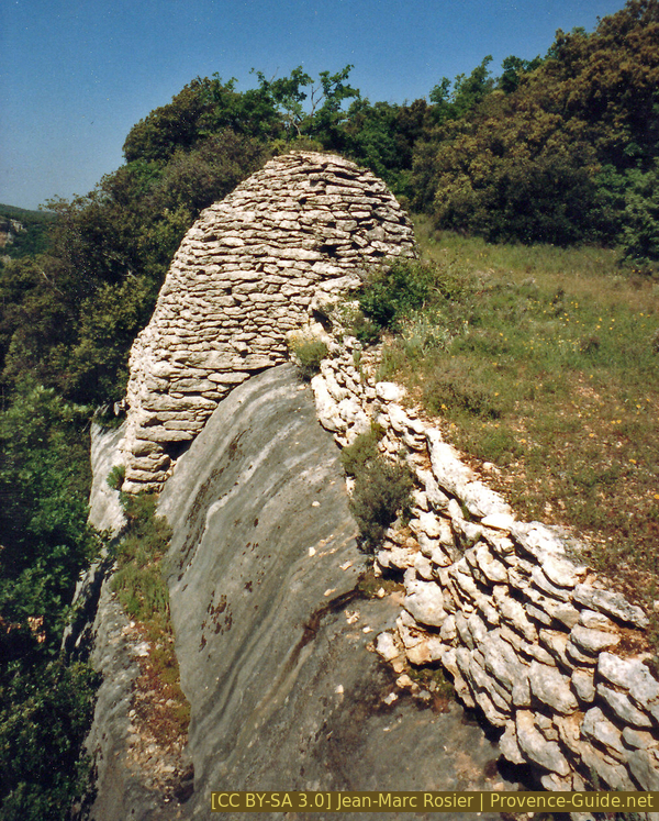
Through the undergrowth, you will soon reach the farm track Piste de la Vachère, here we turn left and thus again with the yellow marking to the south. Turning around reveals another rectangular borie in the hillside. You can climb there, but you have to arm yourself against quite prickly undergrowth. Below the dry stone building are other ruined structures, as well as pools carved into the rock.
Turning right on the road, you can make a detour to the Carroufra farm, built into the rock. However, later on along the way we can look back on these historic building.
No reproduction is permitted without the written consent of the author. (id3234)
Borie with opposite corbelled vaults
In front of us we see the La Vachère farm. Fruits are grown here. Our marked path branches off to the left into the forest just before the farm.
Section 3: La Vachère - Saint Gens
➙ 3,2 km ... 1 h 10 min ➚ 100 m ➘ 120 m ↝ average
5% cross country, without marks
10% easy trails, few marks
5% easy trails, without marks
15% dirt roads, without marks
20% quiet side streets, few marks
40% easy trails, few marks
The clues
- La Vachère, 420 m
- Carroufra valley, 405 m
- Lou Planestéu saddle, 422 m
- Saint-Gens, 390 m
Several former farms under rocky outcrops.
We come to the south of the La Vachère farm, on the border between the forest and the orchards.
The marked path leads left into the valley of La Combe Mayaud, but we continue straight ahead. It climbs a little, still we go on the border between the forest on the left and the fruit trees on the right. Our path leads us to a wider path, here to the right and so we go north along another rock wall foot.
No reproduction is permitted without the written consent of the author. (id3236)

La Vachère farm
ferme troglodytique = cave farmstead
cuve vinaire = must stone basin
digue = dam
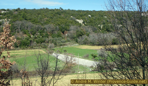
In the picture you can see the edge of the rock, which we will walk along below, from further behind.
No reproduction is permitted without the written consent of the author. (id3237)
Vallon de la Carroufra
Very quickly we come to a temporary but derelict cave house. It is a whole farm built under the rock overhang.
No reproduction is permitted without the written consent of the author. (id3239)
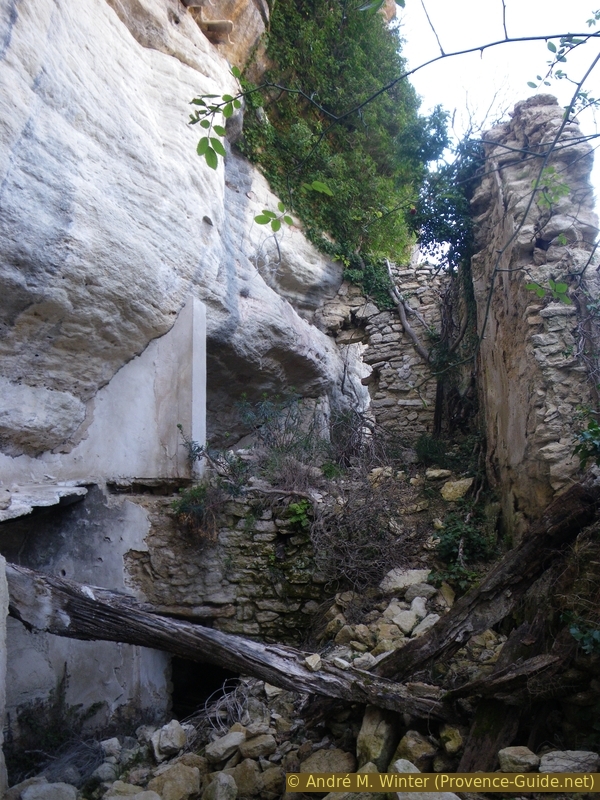
Ruined Carroufra cave dwelling beneath a ledge
Attention, the masonry is very badly damaged because all the wooden beams have rotted away. Inside you will find two old horse-drawn carriages.
No reproduction is permitted without the written consent of the author. (id3238)
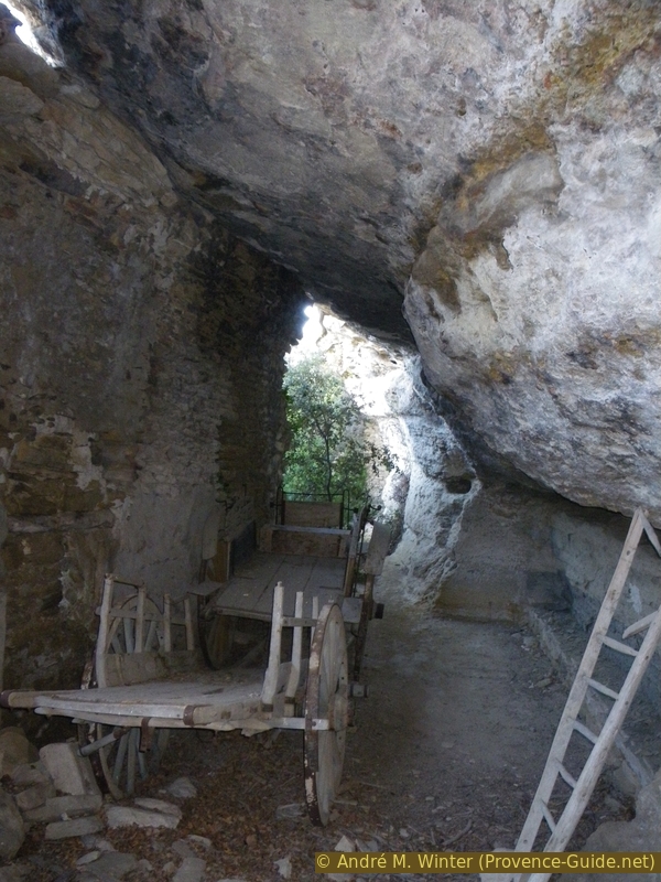
Old wagons in the ruins of Carroufra under the ledge
A few meters further on you can see a stone cone on the right side of the path. It is another must stone basin, here the superstructure has partially collapsed. But the pool is clearly visible.
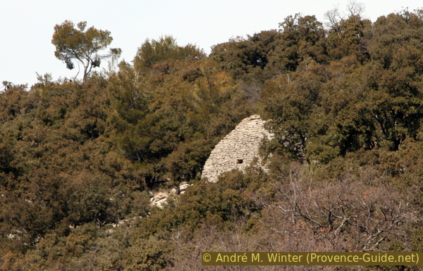
A little further you have a good view across the valley. Opposite you can see the cave farm Carroufra. The recesses in the wall in front contained beehives (second photo at the top of this page).
No reproduction is permitted without the written consent of the author. (id3240)
Must basin of the Bergerie troglodytique de Carroufra
The fields in the valley are delimited with large stone walls. But these are not just retaining walls, they are real dams that hold back the earth in heavy rain and thus actively filter the water.
No reproduction is permitted without the written consent of the author. (id3241)
Dry stone partition dam in Carroufra Valley
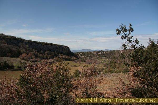
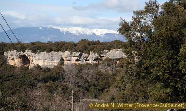
After all these sights we come to an asphalt road, here to the left. After a first left turn, do not turn left again to the Clapeyrouse estate, instead we go straight ahead on the marked trail to St. Gens. At a tight bend you pass the ridge Lou Planestéu and you go down along natural earth pyramids. The name is not entirely correct as these formations are made entirely of solid limestone like the Mourres de Forcalquier.
No reproduction is permitted without the written consent of the author. (id3243)
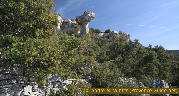
Rock towers at Saint-Gens
A little further down we pass another stone hut, then we come to another house half built into the rock wall. Part of it has been repaired and is now inhabited. Continuing downhill, we come to a tight bend in the D39a road.
At the bottom of the ditch is the hermitage of St. Gens. You can also make a detour up to the spring that is at the origin of the hermitage.
No reproduction is permitted without the written consent of the author. (id3244)
Court under a ledge at Saint-Gens
Section 4: Saint Gens - Le Beaucet
➙ 4,6 km ... 1 h 40 min ➚ 100 m ➘ 250 m ↝ easy
15% quiet side streets, few marks
25% easy trails, few marks
40% quiet side streets, few marks
20% city alleys, without marks
The clues
- Saint-Gens, bend of D39a road, 390 m
- La Borie Noire, 460 m
- La Grande Cabane, 385 m
- Le Beaucet, 240 m
Other shelters in drywall style.
From the bend above the hermitage we continue uphill to the west. You pass under a stone tower topped by a figure of a saint, probably St. Gens. The road climbs the slope, but at the same time leads into the steep valley. Once there, the marked path turns to the right (signpost). When you get to a quarry, you've gone too far west on the road.
No reproduction is permitted without the written consent of the author. (id3245)
Ascent along a quiet road above St. Gens
View back.
This path leads us to a wooded hill. A transformer building clad with natural stone is located on the north-facing ridge of the site. Behind, in the direction of the power lines, is the so-called Black Borie (Borie Noire), another large dry stone construction on a rectangular base.
No reproduction is permitted without the written consent of the author. (id3246)
Cliffs of the Grande Combe and snowy Mont Ventoux beyond
Now back to the transformer and take the trail swinging north-west and onto a narrow tarmac road that will accompany us further back to Le Beaucet. Shortly thereafter follows a signpost and to the left of the road follows the Grande Cabane, which is also a very large rectangular borie. Like the others, it probably served as a seasonal storehouse or stable.
No reproduction is permitted without the written consent of the author. (id3247)
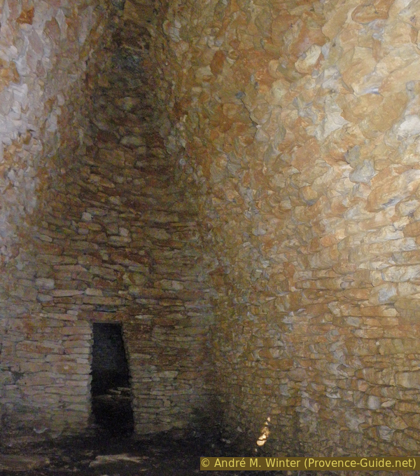
Inside Grande Cabane
château = castle
The small road takes us to Le Beaucet. When it makes a sharp left turn, we continue straight ahead on the dirt road. Under the village and under the associated castle we come to an oversized cairn, which was erected as a monument by the organization APARE. These folks lovingly restore old dry-stone buildings.
No reproduction is permitted without the written consent of the author. (id3248)
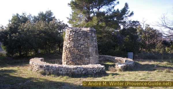
Large cairn for the 20th anniversary of APARE
The castle ruins are very close and we are at the only access onto. We use the chance above all for the great view that you have from the top to Carpentras.
No reproduction is permitted without the written consent of the author. (id3249)
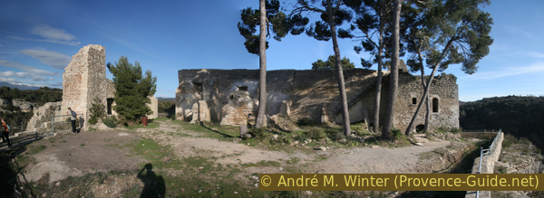
In the ruins of Le Beaucet castle
The church of Le Beaucet dates from the 12th century, the original octagonal bell tower supports a free-hanging bell in a wrought iron frame, such a campanile is typical of Provence.
No reproduction is permitted without the written consent of the author. (id3250)
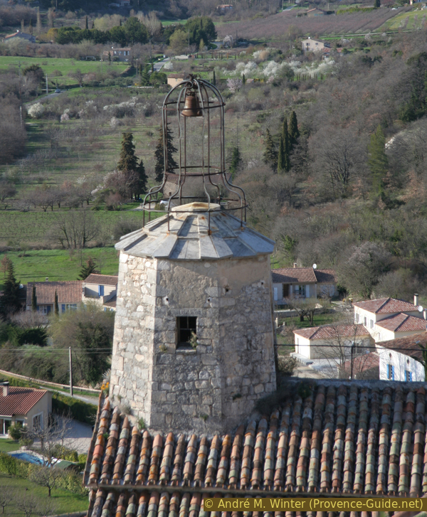
Octagonal tower of the Le Beaucet church
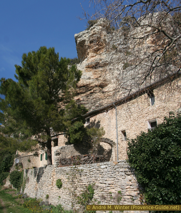
However, we don't yet have an overall impression of the village as a large part of it is built under a rock wall. The castle ruins are enthroned on top. We leave the castle area and we take the first path on the left. It runs parallel to the path on which we came to the village. We climb 400 meters slightly before we come down again on the left over the Chemin de l'Alouette.
Below you can see many dwellings built in semi-caves and overhangs.
If we continue straight ahead, we come directly to the starting point at the cemetery.
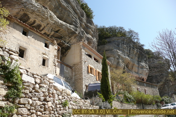
Cave houses at Le Beaucet
Sources and additional information
This walk is inspired by the book 25 balades sur les chemins de la pierre sèche (25 Hikes on tracks of the dry stone constructions, only french) by Florence Dominique. Éditions Le bec en l'air, ISBN 987-0-916073-45-3. The book also contains detailed explanations of the various dry stone buildings in the Monts de Vaucluse, Lure and Lubéron region.
A good topographic hiking map is a better guide: this tour is on the IGN map "Cavaillon, Fontaine-de-Vaucluse, Parc du Luberon", scale 1:25000, 3142OT.
If you don't want to bother with a paper map, you can also use mapping apps on your cell phone. On the one hand, it is the Géoportail app from the official map service IGN. However, it requires access to the data network and this is sometimes difficult in canyons or remote locations.
Alternatively, you can use apps that store data directly on the device. They're generally not free, but they don't cost much. We mainly use OSMAnd, here it is possible to add contour lines, relief shading, markings and others. To store this data on your phone you need a lot of space.
Of course, one needs access to satellites for the GPS signal with any app. In some canyons this is not the case. Therefore, do not rely on the position shown, but read the map on your phone as you would read it on paper. Most apps are available for Android and iPhone. The applications usually allow us to record the route travelled and also view the GPS files offered for each of our hikes.
This page has been seen 216 times since 20 March 2024.