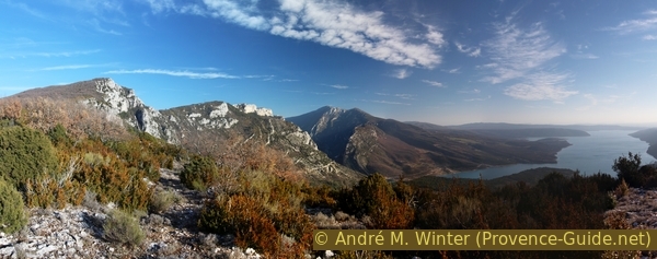
North edge of the Verdon Gorge and sinter landscape of St. Maurin
Ascent in the north flank of the Verdon and back over the long ridge
hike
average
5 h min
far
yes
no
mountain
Introduction
This tour at the exit of the Verdon Gorge and high above the Sainte-Croix lake offers magnificent views, which are far more impressive here than from the roads below. There is a total of more than 1000 meters of altitude to overcome, and you often hike in the sun. An important natural phenomenon awaits us halfway: a spring with limestone deposits flows through the dense forest in a bed of tuff.
On this tour, you walk more than five kilometres directly on the edge of the ridge above the Verdon and the Sainte-Croix reservoir. The view from up there is really worth the effort.
In contrast to the tours in the main gorge, you also have a view of the entire lake here.
The facts
13,4 km total distance
5 h min walking time
1110 m total elevation
orientation easy, but important branches are not marked
mark 65% of the total distance
60% easy trails
15% moderate trails
10% cross country
10% country road
5% forest roads
dangers heat in summer, fear of heights, pine processionary moth
children if they have appropriate walking experience
useful picnic stuff
required hiking boots, hiking equipment and water
GPS coordinates (WGS84) of start and end point 43.828188,6.228047
downloads ![]()
![]()
No reproduction is permitted without the written consent of the author. (id3802)
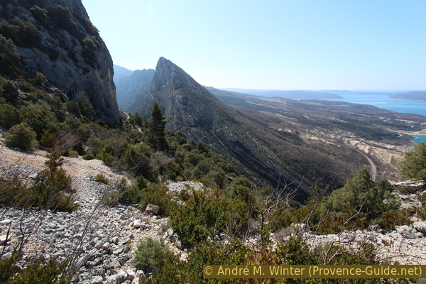
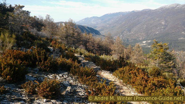
Crête de l'Ourbes, Crête de l'Issioule, Margès and the Lac de Ste. Croix
View from the way back along the ridge line.
Public transport
The bus line 450 runs between Castellane and Riez. However, the connections are constantly changing and are far from perfect. All buses either stop in the village of Moustiers-Sainte-Marie or a stop on the regional road below.
Information on Zou! (only french). The public transport offer around the Verdon is honestly lousy.
plateaux calcaires = lime plateau
Maison du Parc = Park house
To get to the starting point: from the village of Moustiers, go down the ramp by the Côté Jardin restaurant (signpost GR4) and then towards the D952 road, the regional road stop is at the crossroads. Cross the main road and follow the GR4 markings on Chemin de Quinson and Chemin de Peyrengue. Back on the regional road, we follow it in a southerly direction for about 500 meters (you will pass the St. Pierre chapel) to the roundabout, turn left there and take the marked and uphill path that intersects the hairpin bends of the road to Castellane.
No reproduction is permitted without the written consent of the author. (id3781)
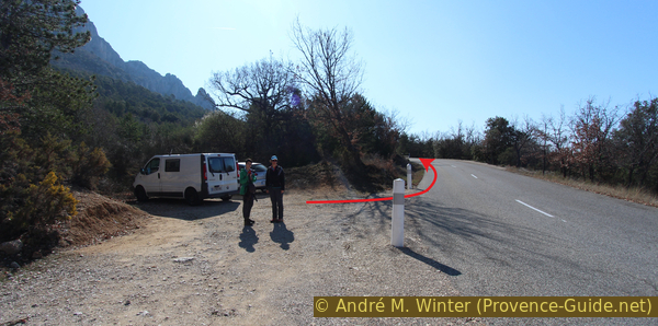
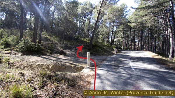
Starting point at the old quarry
Cross the street once and when you come back onto it, you come across a small parking lot. The main tour is described from here. You have to calculate about 3 kilometres more for this ascent.
Access by car
The starting point is near Moustiers-Sainte-Marie and at the beginning of the Castellane road that runs along the north bank of the Verdon Gorge. By car, from the roundabout at the Saint Clair campsite, drive up to the third hairpin bend (there are some parking spaces on the outside of the hairpin bend).
Useful parking spaces
About six places right at the starting point, about 15 places on the curve down (at the picnic area), a few places on the following curve. There is also parking at the regional park house south of the roundabout. From there, a path that cuts off the hairpin bends leads directly up to the starting point.
Hints
It is a challenging tour with some exposed spots and rocky passages. The main challenge remains the heat (south orientation) and the fact that total vertical gain is a result of repeated ascents and descents.
The tour ends with a long descent of 600 meters, from which one is tempted to choose this as an ascent. However, there are two reasons why the anti-clockwise tour is recommended: the climb to Col de Plein Voir is steep and the rubble is easy to slide on, and going in the opposite direction has the boring road at the end. This section is easier to master with full energy at the beginning of the day.
In winter you can leave until 10 am, in summer you should be at the starting point by sunrise. A rather early departure also avoids too much traffic on the road, which one has to follow at the beginning. In the morning there are few and only uphill cars.
The whole region is a zone with a high risk of forest fires. In summer, but also in other seasons when it is very dry or strong winds, access to the forest areas can be regulated. As a result, the roads may be closed to traffic and/or the trails prohibited to hikers. Current information: Access map to the forests of Alpes de Haute Provence (only french). The map shows the colours green, yellow, orange and red which correspond to levels of danger.
The pines on the sunny sides suffer from the pine processionary caterpillars. The fine stinging hairs are particularly dangerous for humans. These hairs fall from the nests in the trees, especially when it is windy, and whirl through the air without losing their irritating effectiveness. This is especially true in spring and well into early summer. One should never touch the caterpillars or the nests. The hairs cause severe itching like nettles, but the effect comes later and lasts for several days. The caterpillars can be deadly to dogs because their tongues can become swollen.
The sections
- Old quarry (Ancienne carrière) - Coteau des Félines: go towards the gorge
- Coteau des Félines - St. Maurin: between the gorge and the re-emergence of the spring
- St. Maurin - Col de Plein Voir: ascent to the main ridge
- A lap on the ridge
- Col de Plein Voir - Crête de l'Ourbes: back on the ridge with the last climb
- Crête de l'Ourbes - Ancienne carrière: back on a long descent.
Bars and inns only in the villages of Moustiers and Aiguines. In the summer there are snack stalls on the beaches by the lake.
No reproduction is permitted without the written consent of the author. (id3794)
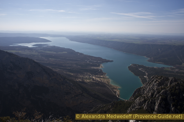
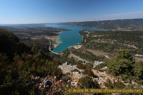
Lac de Sainte-Croix seen from the Crête de l'Issioule
Section 1: Ancienne carrière - Coteau des Félines
➙ 3,3 km ... 1 h min ➚ 240 m ➘ 82 m ↝ average
35% country road, without marks
25% forest roads, without marks
40% easy trails, without marks
The clues
- Parking at the former quarry (ancienne carrière), 565 m, start in the hairpin bend
- Follow the D952 uphill on foot
- Beginning of the forest road on the left parallel to the road, 615 m
- Follow the D952 uphill again
- Beginning of the trail in the Bois des Félines forest, 665 m
- Coteau des Félines, 665 m
The beginning of the tour takes you along the Castellane road and partly above it, but this way you can avoid the road on the way back. The forest roads and paths are not marked in the beginning.
vers = to
rond-point = roundabout
crête = ridge
In the Verdon area you can rarely walk circular tours, often you have to take uninteresting climbs. But at the end of this tour we descend directly back to the starting point. Said quarry cannot be seen from the road, but we will see the remains at the end of the tour.
The direction to follow from the parking lot by the old quarry is easy. We stay 700 m directly on the road. In a long right-hand bend, a forest road branches off to the left under a high-voltage power line. There we go up and find ourselves a little above the road. We move towards the east, ignoring the paths that go up to the left. There are no markings here, but you follow green signs on a white background on the trees, which mark the boundaries of forest properties.
No reproduction is permitted without the written consent of the author. (id3782)
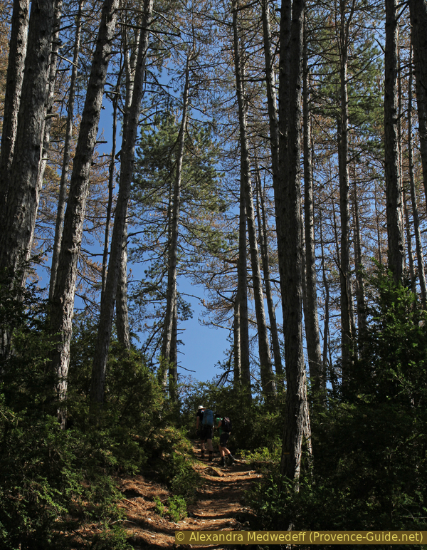
First climb on a path parallel to the Castellane road
After about 10 minutes you come back to the street for a short time. In the following right-hand bend we climb left again up into the forest.
But be careful: do not take the old passable dirt road that lead vertically up from the road into the valley. You have to take the path at the end of the bend that runs parallel to the direction of the road.
No reproduction is permitted without the written consent of the author. (id3783)
Further ascent from the road on the Bois des Félines path
This brings us to the first official signpost in the Bois des Félines (there is a car park further down the road here). From here our tour is marked in yellow. At the crossroads you have to cross the forest road and take one of the descents, which accounts for part of the many meters of altitude on the tour. You come again above the road to the signpost in the Coteau des Félines.
Section 2: Coteau des Félines - St. Maurin
➙ 1,6 km ... 45 min ➚ 220 m ➘ 140 m ↝ average
60% easy trails, few marks
40% moderate trails, few marks
The clues
- Coteau des Félines, 665 m, above the road
- Passing through the water gap at the end of the Verdon Gorge, 770 m
- Torrent with sinter basin near St. Maurin, 770 m
After the sections on the road, we climb slightly to cross the final bottleneck of the Verdon Gorge and find the unique waterfalls of Saint-Maurin.
No reproduction is permitted without the written consent of the author. (id3784)
Passage high above the Pont de Galetas
After the rather straightforward ascent, the interesting things begin. We see that our path will pass through the Galetas narrows around a hundred meters above the road and more than 300 meters above the Verdon. However, from here we do not see how the old path between the rocks will continue. The trail uses the ledges to lead through the narrow passage at the gorge exit. There are few yellow markings here, but the steepness of the terrain does not allow for any alternatives to the path anyway.
No reproduction is permitted without the written consent of the author. (id3785)
Scree heap above Galetas
Following the edge of the rock, the view of the lower section of the Grand Canyon du Verdon opens up.
In summer, the pedal boats and electric boats turn around at the canyon exit, since the Lac de Sainte-Croix is dammed back into the gorge up to there. In the photo at the back: the cirque de Vaumale and the Grand Margès mountain. Left of the river: the Castellane road.
No reproduction is permitted without the written consent of the author. (id3786)
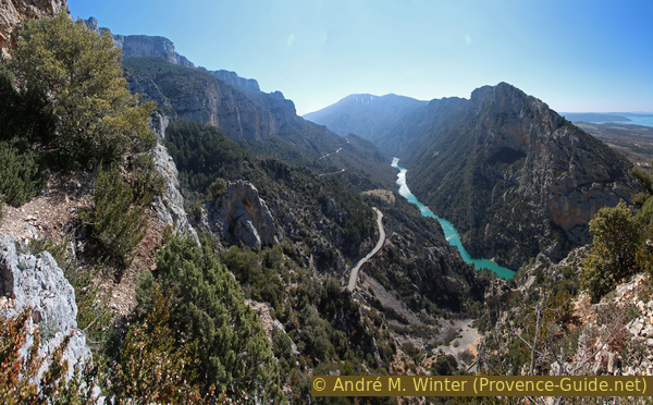
Gorges du Verdon between Galetas and Maireste
In the Cirque de St. Maurin, our path goes up and down into a denser pine forest. Here we pass more rocks, without reaching a significant difference in sea level. During a final descent through even denser vegetation, we hear the babbling of a stream. This is amazing, especially in such a dry environment. Although it may be totally dry here during summer.
No reproduction is permitted without the written consent of the author. (id3787)
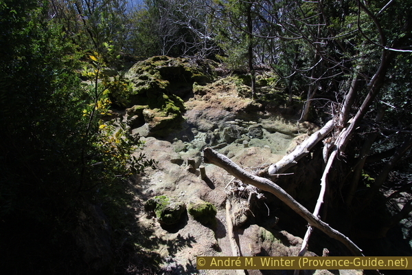
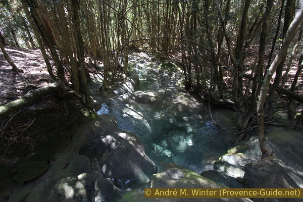
Sinter basin at Saint Maurin
Opposite a yellow marker on a rock, a path leads through the bushes to the lower part of the St. Maurin waterfall. Those familiar with the Castellane road below may recall the tuff waterfall on the retaining wall just down the road. This is the much nicer part upstream. The creek bed offers deep pools with crystal clear water, the colours change between turquoise and green. You can go up the tufa slide, it is not slippery where there are no algae. However, one should not trample unnecessarily on the wonderful formations.
Attention: the nature reserve of Saint Maurin is a specially protected area within the Natural Park of the Verdon. Access is free, but you are advised to stay on the paths. Bathing, spending the night or making a fire is forbidden!
We go back up the marked path and a little further up we come to a flatter area where it is possible to approach the interesting watercourse again. Here it gradually floods the tree trunks.
No reproduction is permitted without the written consent of the author. (id3788)
Torrent and tuff in the forest of the Cirque de St. Maurin
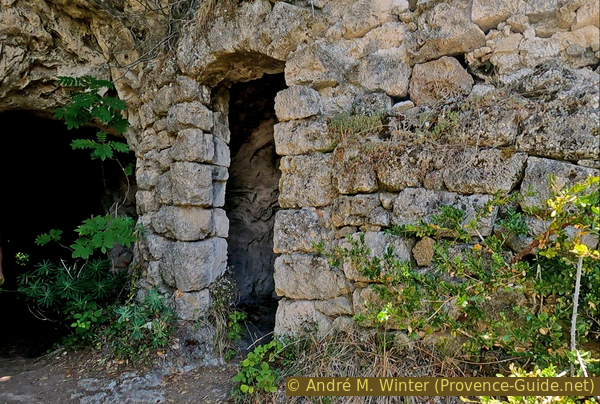
About 70 meters above the point where you first came to the watercourse, there is the possibility to traverse to the right onto a more open plateau. Here are ruins in built caves. On the other side of the river are a multitude of paths, but without very useful markings. The large green signs mark forest limits, in our case they also mark the forbidden access zone further above. The GPS and KLM tracks included earlier on this page also contain the track described below. Be aware though that the GPS signal is very poor here and the trails change often. There are basically three levels under a large meadow. The small cave is below the level of the meadow, the larger one is one floor deeper.
We cross the bed of the river without a path or footbridge. Continue perpendicularly until you come to a path and follow it to the right and down. You go down one level and then turn left to follow a balcony path in the tuff. The photo shows the looking back. This path then turns 180 degrees down and to the right to bring us to the largest troglodyte cave in St. Maurin.
No reproduction is permitted without the written consent of the author. (id6367)
Balcony path under the upper meadows of St. Maurin
There is evidence of human occupation probably since the 5th century. There are two large caves made into cave dwellings, the Big Cave and the Walled Cave are of more recent origin, mentioned in the will in 1611 of the lord of La Palud. An abundant annual supply of water has benefited human occupation and remains of ancient irrigation channels shows also agricultural activity on the terraces.
Tufa looks porous, it is a light rock easy to carve. It was used widely in local villages to make key stones, and door and window surrounds in churches and stone houses.
No reproduction is permitted without the written consent of the author. (id6368)
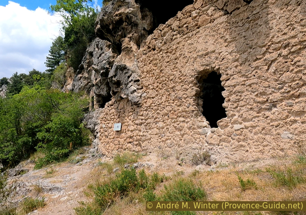
Large St. Maurin cave dwelling
We leave the big cave as we came there, but we continue to descend along caves in the cliff and we arrive in a green and humid area. You walk directly on the soft tuff, you have to stay on the path and the footbridges. We are here under another waterfall which also flows in summer. We get closer to the road and we come to a path fork where we turn left. We go up and go to a higher level. Here we cross a small stream which forms the waterfall under which we had passed just before. Be careful, nothing is secured here. We continue and we arrive on a large meadow where a historic farm is dug out. In June 2022, work was in progress here. We pass the heaps of upturned earth and we continue in the same direction without walking up. We arrive on a kind of ledge which leads us after a few meters to the second troglodyte cave. It is much smaller.
No reproduction is permitted without the written consent of the author. (id6366)
Small cave dwelling under the upper meadows of St. Maurin
After the second cave, we continue in the same northwest direction and back towards the river bed. Shortly before the river, the vegetation intensifies and the paths are no longer very easy to recognize. We want to walk up along the river. When it's dry it's easier, when there's water it's better not to cross it first. We can climb like this until the resurgence. These are two holes in the rock wall in a cirque surrounded by vertiginous rock walls.
To return to the main path, you have to descend along the bed of the river and cross it as soon as possible.
No reproduction is permitted without the written consent of the author. (id6365)
Cliff of Barbin above the resurgence of St. Maurin
Section 3: St. Maurin - Col de Plein Voir
➙ 1,4 km ... 1 h min ➚ 360 m ➘ 20 m ↝ easy
40% moderate trails, few marks
60% easy trails, few marks
The clues
- Saint Maurin, 770 m
- Path under the rock wall
- Viewpoint, 1035 m
- Col de Plein Voir saddle, 1170 m
We now face the main climb up the north ridge of the Gorges du Verdon. We are basically in the shade here, but the sun is also heating up a lot under the pine trees.
Up to here we haven't really gained altitude, this is the moment to take a deep breath and climb up to the edge of the Barbin plateau more or less in one go. The slope is very steep and for a long stretch we will climb old screes and rocky outcrops.
No reproduction is permitted without the written consent of the author. (id3789)
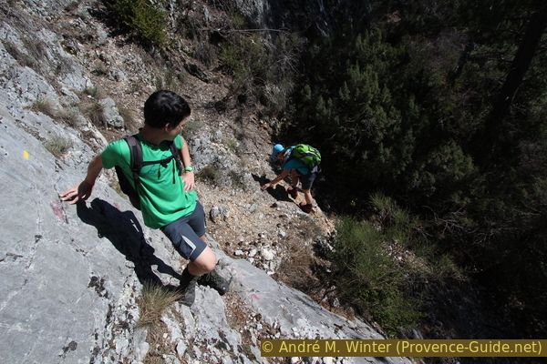
Rocky spot in the upper Cirque de Saint Maurin
The solid rock in the foreground isn't a problem, but the scree below is unstable.
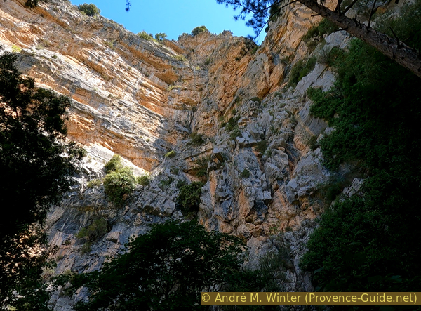
We then approach an impressive vertical cliff on the right. It shows us that the valley we are going up is getting narrower and narrower.
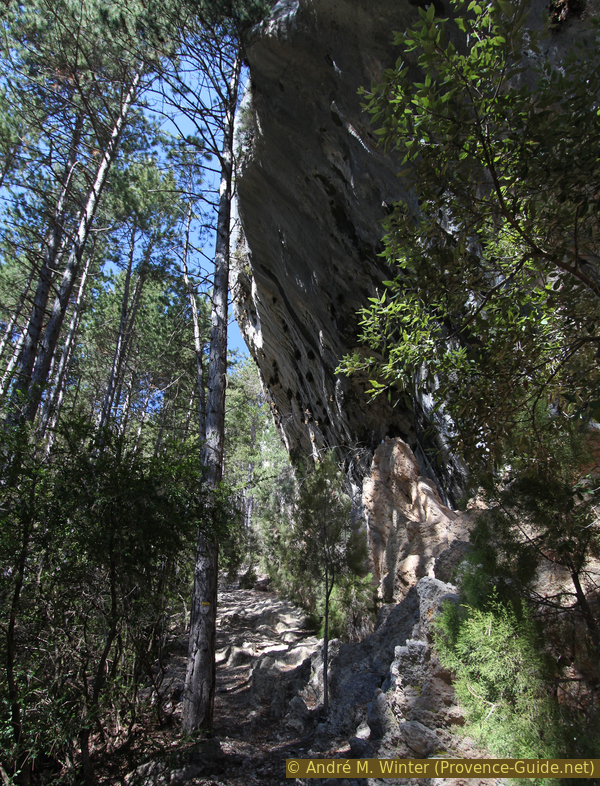
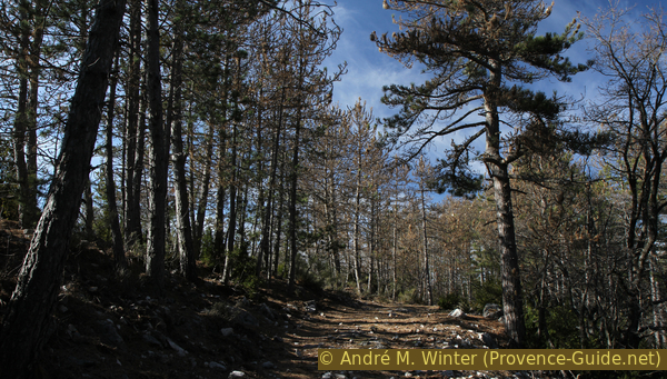
The path then leads through a forest with large pines.
No reproduction is permitted without the written consent of the author. (id3790)
Cliffs in the Cirque de St. Maurin
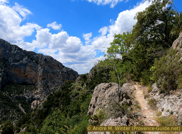
The path heads north and climbs to the ridge at the level of the gorge exit and to a viewpoint at around 1020 meters. Don't try to climb the rocky ridge on the left (west), the view doesn't get any better from there and the ridge is very exposed. A path that was supposed to lead north from here under the Col de l'Âne was not visible in 2016.
Our marked path turns east and is almost flat at first in high forest. There are still a few meters to go before we go straight up to the Col de Pein Voir. The saddle itself doesn't quite have the right name (Plein Voir = full view) but a few meters to the right the ridge is clear of trees and the view opens up over the Verdon to Maireste, the Grand Margès, looking to the north one sees the Chiran and east until Châteauneuf-lès-Moustiers.
No reproduction is permitted without the written consent of the author. (id3791)
Few metres before the Col de Plein Voir saddle
Section 4: Crête de l'Issioule
➙ 2 km ... 45 min ➚ 80 m ➘ 80 m ↝ average
65% cross country
35% easy trails, with marks
The clues
- Col de Plein Voir saddle, 1170 m
- Ridge with a pole, 1250 m
- Descent north to the GR4 long-distance hiking trail
- On the GR4 back to the Col de Plein Voir saddle, 1170 m
We follow the ridge de l'Issioule to see the Verdon further upstream.
No reproduction is permitted without the written consent of the author. (id3793)
On the Plateau de Barbin
col = pass
crête = ridge
pilier = pole
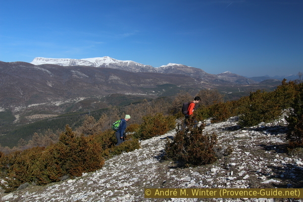
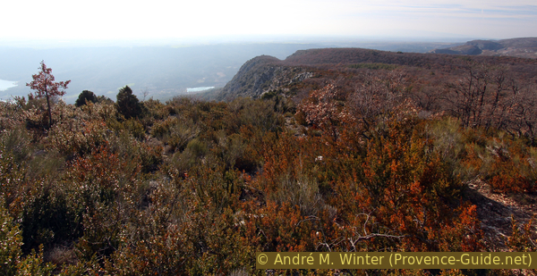
To get a better view of the Verdon and its impressive cliffs to the north, you can continue along the Issioule ridge, which is sparsely wooded here, but you should always keep a safe distance from the precipice. There is no marking here. We go to the point where a concrete pillar is clearly visible. This is not the highest point of the ridge, but it offers the best view.
Fossilized ammonites are common in the Southern Limestone Alps. If you spend more time in the region, we advise you to go see the Ammonite slab at Digne-les-Bains.
No reproduction is permitted without the written consent of the author. (id3792)
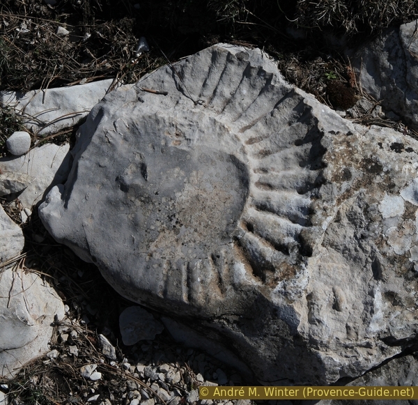
Ammonite fossil near the Col de Plein Voir saddle
Sheep graze on the plateau. In the background the Grand Margès, which stands south of the Verdon.
No reproduction is permitted without the written consent of the author. (id3795)
Issioule ridge with sparse vegetation
To get back to the Col de Plein Voir, you can either return along the path on the ridge or descend north until you come to the GR4 path, which is clearly visible. Turn left here and go back in an almost direct line and level to the Col de Plein Voir.
No reproduction is permitted without the written consent of the author. (id3796)
GR4 long-distance hiking trail on the Barbin plateau
Section 5: Col de Plein Voir - Crête de l'Ourbes
➙ 1,7 km ... 30 min ➚ 100 m ➘ 80 m ↝ easy
80% easy trails, with marks
20% moderate trails, with marks
The clues
- Col de Plein Voir, 1170 m
- Col de l'Âne, 1095 m, with high-voltage power linesn
- Highest point of the Crête de l'Ourbes, 1210 m
We take the return route that goes directly along the ridge and over the Col de l'Âne for more than 4 km.
From the Col de Plein Voir we head north into a pine forest on a wide path. Here we almost imperceptibly climb a wooded hill called Plein Voir before descending under squat pine trees into the Col de l'Âne.
No reproduction is permitted without the written consent of the author. (id3797)
GR4 long hiking trail on the Col de Plein Voir saddle
Before the Col de l'Âne we pass high-voltage pylons. At the saddle there is a crossroads with a signpost: on the left, a path leads down to the Bois des Félins, but this is less exciting and you would have to go back along the road. On the right, an unmarked path leads into the wild valley of Vallonge and straight ahead our GR4 leads back to the starting point of the tour.
No reproduction is permitted without the written consent of the author. (id3798)
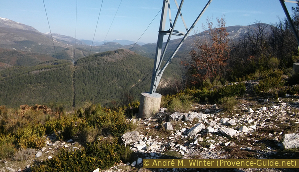
One of the high-voltage power lines on the Col de l'Âne pass
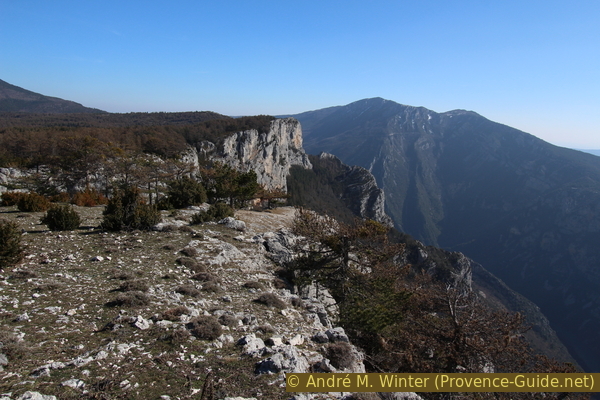
At first glance you might think that you can't go any further here, there is a steep climb right in front of you, which you could clearly see from the descent to the saddle. But that's just a psychological effect, we've already covered a great distance and here you have to climb 120 meters up the crest of l'Ourbes. But the path is visible, well marked and always a little to the right of the cliff, but mostly in the rock. And of course it's uphill, but this is the last time!
No reproduction is permitted without the written consent of the author. (id3799)
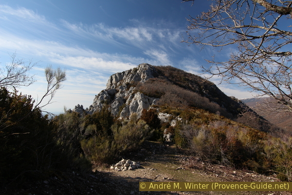
The southern and steeper part of the Crête de l'Oubres
The highest point of the Crête de l'Ourbes is covered with oak trees, there are some paths to the south but the view doesn't really get any better. There are other and better vantage points ahead.
No reproduction is permitted without the written consent of the author. (id3800)
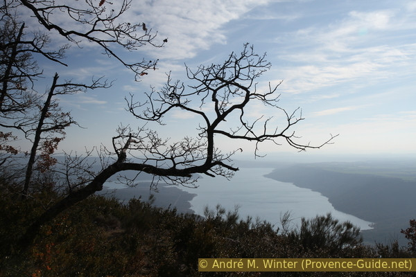
Strage tree and the Lac de Sainte Croix
Section 6: Crête de l'Ourbes - Ancienne carrière
➙ 3,5 km ... 1 h min ➚ 100 m ➘ 720 m ↝ average
85% easy trails, with marks
15% moderate trails, few marks
The clues
- Crête de l'Ourbes, 1210 m
- Between rocks and cliffs, 860 m
- Car parc at the former quarry (ancienne carrière), 565 m
The descent from the ridge above the Bellière farm leads through crevices in the rock face.
It goes downhill along the Crête de l'Ourbes in one go, with more than 600 meters of altitude difference to overcome. But the descent is varied, after a last summit there is a rather flat part before we come back to rocky areas.
No reproduction is permitted without the written consent of the author. (id3801)
Flat section of the Crête de l'Ourbes
ancienne carrière = former quarry
vers rond-point = to the roundabout
crête = ridge
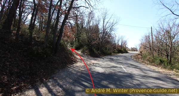
The course of the path is pleasant, only now and then large stones make walking difficult. There is only one spot that is a little badly marked, and that is before a steep descent. An old laid stone path leads to the left to pass a rocky outcrop, but we have to descend to the right into a steep valley that at first seems a bit overgrown.
No reproduction is permitted without the written consent of the author. (id3803)
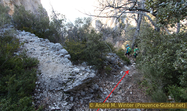
Fork on the trail with a dead end on the left
We come to a hollow and take the last counter climb of a few meters to pass between two large rocks.
We then enter a pine forest on a path that is sometimes steep and riddled with ditches. Following the remains of a fence, we find ourselves above the old quarry at the foot of which we started at the beginning of the tour.
Those going back to the roundabout stay on the outside of the curve to descend there. To continue to Moustiers, follow the description under public transport in the opposite direction.
Sources and additional information
It is better to use a good topographical hiking map: this tour is on the IGN "Gorges-du-Verdon/Moustiers-Sainte-Marie/Lac de Sainte-Croix" map, scale 1:25000, 3442OT.
If you don't want to bother with a paper map, you can also use mapping apps on your cell phone. On the one hand, it is the Géoportail app from the official map service IGN. However, it requires access to the data network and this is sometimes difficult in canyons or remote locations.
Alternatively, you can use apps that store data directly on the device. They're generally not free, but they don't cost much. We mainly use OSMAnd, here it is possible to add contour lines, relief shading, markings and others. To store this data on your phone you need a lot of space.
Of course, one needs access to satellites for the GPS signal with any app. In some canyons this is not the case. Therefore, do not rely on the position shown, but read the map on your phone as you would read it on paper. Most apps are available for Android and iPhone. The applications usually allow us to record the route travelled and also view the GPS files offered for each of our hikes.
This page has been seen 475 times since 20 March 2024.
No reproduction is permitted without the written consent of the author. (id3804)
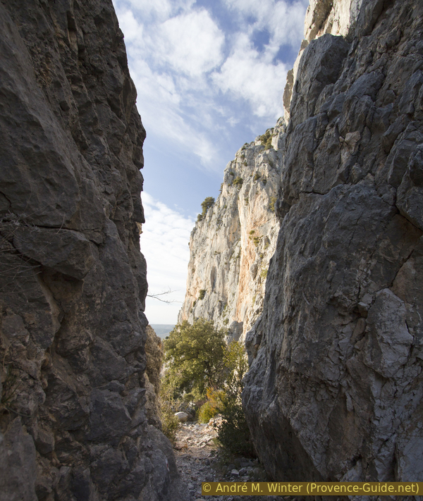
The GR4 trail goes through a cleft in the Crête de l'Ourbes